Cherohala Challenge

It was great returning to Tennessee on June 20th, 2009 for my fourth road biking century in this not so flat State. For this trip we exchanged three years of rain and thunderstorms in Chattanooga for record high temperatures and heat index, dry pavement and plenty of sunshine. Tellico Plains, TN is the host city for the Cherohala Challenge; a 115 mile, 9,000 feet of climbing road century. Tellico is located on the Western edge of the Cherokee (Tennessee) & Nantahala (North Carolina) National Forests. Joining me for the ride were fellow Rootstockers Greg and Kevin along with Doug Patterson and my brother Paul. (Elizabeth Grossart joined us for the weekend and she rode the metric century route.)
In summary, notwithstanding the heat and other than an 18-24 hour adventure race, this event was easily one of the hardest events I have done.
Our cabin for the weekend was about a one mile ride to the start, apart from a bridge overpass, all of which was downhill. I arrived at the staging area a little before the 7am start already sweating, even after coasting the entire way down from the cabin. It was 77 degrees with a forecasted record high of 95. (Actual high reached: 96 with a 114 heat index).
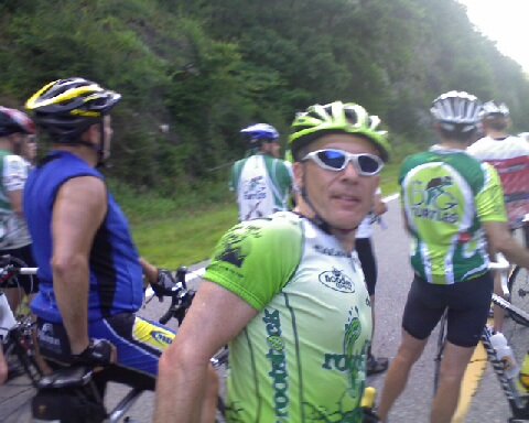
Start to SAG#1 (21 miles) About 500 riders were signed up for the Challenge. The ride to SAG#1 was very similar to an Indiana weekend CIBA training ride. The pack rolled away slowing breaking into smaller groups of similar riding abilities. My plan was to fall into a group with a nice pace but not too fast. I knew I had a long day ahead of me and wanted to be as efficient as possible. The miles went fairly fast as this section of the ride was on the flat side with very small rolling hills. The only hitch being when our group of about 30 riders missed a turn and rode about a mile out of our way. After some heated discussion among two of our groups’ riders on which way to go, a local drove by and provided directions. It turns out that both the roads the two riders wanted to ride on were wrong and the driver was right. Now back on the correct route, the group made good time to SAG#1. Facilities were a bit lacking. The event organizers had but two port-o-lets and I was stuck in line when my group rolled out of the SAG. Bummer! Paul, Doug and Kevin rolled into the SAG shortly thereafter so I joined up with them.
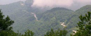
SAG#1a (44 miles) A few miles after leaving SAG#1 a small group of about 7 riders rolled by me at what appeared to be a “nice efficient pace” for me so I hopped in with them saying goodbye to Kevin, Paul and Doug. This turned out to be a fun group and we cruised along a large lake rolling towards the infamous “Tail of the Dragon,” a well known road popular with motorcyclists having over 300 turns in 10 miles of beautiful and hilly mountain roads. This SAG, “1a” was added at the last minute due to the heat and after a quick fill up of water our group was off.
 Unfortunately about 1 mile before the climb up thru the Dragon, a police car stopped all traffic on the road. The forest service was using helicopters to move large earth moving equipment from one mountain to the next and closed the road for about 20 minutes. By the time we were cleared to ride, the traffic had back up with about 100 riders, 30 plus cars and well over 50 motorcyclists heading towards the Dragon. The initial part of the climb was a little crazy with all the traffic but it quickly spread out and the riders were able to enjoy the long climb up to SAG#2 which was also the North Carolina state line.
SAG#2 (54 miles) By my arrival at SAG#2, our riding pack was gone and most riders were in small groups of one or two riders. I was just ready to roll out and enjoy a solo descent off the Dragon when Kevin rolled in. A brief stop for Kevin and we rode off together. The descent was fast and fun. The route passes the dam that Harrison Ford jumped off of in the movie the Fugitive. The roads to SAG#3 appeared to the eye rather flat but the road parallels a river flowing in the opposite direction that we were riding so the uphill grade is not as obvious. Compared to the slow pace of climbing this mileage went rather fast and we quickly arrived at #3.
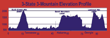
SAG#3 (64 miles, Elev 2050’) Being my first time at this ride one never knows what to expect so I asked a local rider what was ahead and he said “well, let’s just say the easy part is out of the way. Now the real climbing begins.” I remember thinking that if the climb up and over the Dragon was easy, what the hell was ahead. The same local then added “Just pace yourself! The entire Skyway has no shade and it will be a bit toasty up there”
 Your bonus after leaving this SAG is a few miles of small rolling hills before you begin the climb up the Cherohala Skyway, a total climb of 3,300+ feet over 20 miles. Ouch! Just as the local predicted, we turned off a tree covered forest road and onto the Skyway and I thought “who turned on the oven” because it was HOT, not just hot but HOT! Looking ahead you could see the road ramp up the mountain and turn away out of sight. OK it was time to turn on the adventure racers brain! I figured that each of these visual road sections would be just like controls on an orienteering course, just pick em’ off one at a time and you’ll eventually finish the course. (I was told after the ride that it’s about an average 9% grade). So I shifted into my easiest gear, settled into a rhythm and rode on. One “control” done, then the next and next and so on; I wasn’t so much watching the miles on my bike computer go by as I was watching the tenths of miles. The ascent was going along and my legs still felt strong, but the heat was really starting to get to me, there’s not much of a wind chill effect when you’re cruising along at 5.5 mph. Not wanting to get over heated, I pulled over to the side of the road at one of the only shaded spots I could find. I then proceeded to lie down in a dry drainage culvert for about 15 minutes until I cooled off. This must have seemed like a good idea as several other riders rode/staggered over to join me. Once the nausea went away I returned to the bike and rode on until reaching #4, which was less than a mile up the road.
SAG#4 (76 miles, Elev 3550’) My prize for arriving at #4 was some ice cold water, food and a grassy rest spot under a tree. I spent about 20 minutes at this SAG and might have drunk two or three full bottles. I was told by a SAG volunteer that the next three or four miles were the hardest of the day and then the mostly 9% grade ends, still steep but once that was over it “flattens out a bit.” Well those first few miles were only possible due to the now steady breeze that made the conditions feel just a bit cooler! With about two miles to the summit, the road ran through a saddle (or low gap) in the mountain to the other side. It made for a nice change of scenery but now the mountain itself acted as a wind block and the nice breeze was gone. Not good when you’re already nearing a point of seriously overheating. I peddled on this time switching over the bike computer to minutes to judge my progress. “As long as I kept moving, I’ll get there.” Well a very short time later, right next to the road, I spotted a rocky cliff face wet with what I hope for was cold water. I stopped, placed my hand on the rock and it was cold. “Yes! Sir! May I have another” I leaned against the wall, cold water dripping on me and looked out over mountains and knew nothing was going to stop me now. Cooled off, reinvigorated and back on the bike I “hammered” the last few miles at about 6.5mph.
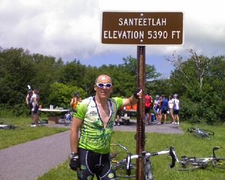 SAG#5 (85 miles, Elev 5390’) Rolling into SAG#5 (Mountain top) was a relief! I made it! I rested a while, restocked the water and grabbed some grub before returning to the bike. Paul made an appearance at this SAG and we rode out together. The remaining 30 or so miles of the ride is mostly downhill with a half dozen or so climbs that are referred to as “the sawtooths,” short ½ mile climbs. This was my 5th century mountain ride (and first one NOT in the rain) so my descending skills are finally improving. I hit 44.63 MPH maximum in this section with long sustained sections over 40, before quickly rolling into SAG#6. The final 7 miles of the climb to SAG#5 took over an hour and fifteen minutes and the 11 mile descent to SAG#6 might have been 15 minutes. That’s just not fair!
SAG#6 (99 miles) I waited for Paul to get to SAG#6 before riding out alone for the final mileage to the finish. The descent on this section was not as fast but nevertheless darn fun as the finish line drew closer. I rode this section completely alone and it was great. By now I was trying to get to the finish with a ride time of less than 8 hours so I was actually hitting it pretty hard considering I had 100+ miles behind me.
Finish & Summary There is just no way to describe the satisfaction you feel completing such a monumental ride. So I won’t even try! Smiles all around and some great post ride chow. Hah! Ride stats came in at 117 miles, 9,154 of climbing, 14 20oz water bottles and 20 E-cap hammer electrolyte tablets. Ride time 7 hours, 59 minutes and 15 seconds. I made it!
In summary, notwithstanding the heat and other than an 18-24 hour adventure race, this event was easily one of the hardest events I have done.
Our cabin for the weekend was about a one mile ride to the start, apart from a bridge overpass, all of which was downhill. I arrived at the staging area a little before the 7am start already sweating, even after coasting the entire way down from the cabin. It was 77 degrees with a forecasted record high of 95. (Actual high reached: 96 with a 114 heat index).
Start to SAG#1 (21 miles) About 500 riders were signed up for the Challenge. The ride to SAG#1 was very similar to an Indiana weekend CIBA training ride. The pack rolled away slowing breaking into smaller groups of similar riding abilities. My plan was to fall into a group with a nice pace but not too fast. I knew I had a long day ahead of me and wanted to be as efficient as possible. The miles went fairly fast as this section of the ride was on the flat side with very small rolling hills. The only hitch being when our group of about 30 riders missed a turn and rode about a mile out of our way. After some heated discussion among two of our groups’ riders on which way to go, a local drove by and provided directions. It turns out that both the roads the two riders wanted to ride on were wrong and the driver was right. Now back on the correct route, the group made good time to SAG#1. Facilities were a bit lacking. The event organizers had but two port-o-lets and I was stuck in line when my group rolled out of the SAG. Bummer! Paul, Doug and Kevin rolled into the SAG shortly thereafter so I joined up with them.
SAG#1a (44 miles) A few miles after leaving SAG#1 a small group of about 7 riders rolled by me at what appeared to be a “nice efficient pace” for me so I hopped in with them saying goodbye to Kevin, Paul and Doug. This turned out to be a fun group and we cruised along a large lake rolling towards the infamous “Tail of the Dragon,” a well known road popular with motorcyclists having over 300 turns in 10 miles of beautiful and hilly mountain roads. This SAG, “1a” was added at the last minute due to the heat and after a quick fill up of water our group was off.
 Unfortunately about 1 mile before the climb up thru the Dragon, a police car stopped all traffic on the road. The forest service was using helicopters to move large earth moving equipment from one mountain to the next and closed the road for about 20 minutes. By the time we were cleared to ride, the traffic had back up with about 100 riders, 30 plus cars and well over 50 motorcyclists heading towards the Dragon. The initial part of the climb was a little crazy with all the traffic but it quickly spread out and the riders were able to enjoy the long climb up to SAG#2 which was also the North Carolina state line.
SAG#2 (54 miles) By my arrival at SAG#2, our riding pack was gone and most riders were in small groups of one or two riders. I was just ready to roll out and enjoy a solo descent off the Dragon when Kevin rolled in. A brief stop for Kevin and we rode off together. The descent was fast and fun. The route passes the dam that Harrison Ford jumped off of in the movie the Fugitive. The roads to SAG#3 appeared to the eye rather flat but the road parallels a river flowing in the opposite direction that we were riding so the uphill grade is not as obvious. Compared to the slow pace of climbing this mileage went rather fast and we quickly arrived at #3.
SAG#3 (64 miles, Elev 2050’) Being my first time at this ride one never knows what to expect so I asked a local rider what was ahead and he said “well, let’s just say the easy part is out of the way. Now the real climbing begins.” I remember thinking that if the climb up and over the Dragon was easy, what the hell was ahead. The same local then added “Just pace yourself! The entire Skyway has no shade and it will be a bit toasty up there”
 Your bonus after leaving this SAG is a few miles of small rolling hills before you begin the climb up the Cherohala Skyway, a total climb of 3,300+ feet over 20 miles. Ouch! Just as the local predicted, we turned off a tree covered forest road and onto the Skyway and I thought “who turned on the oven” because it was HOT, not just hot but HOT! Looking ahead you could see the road ramp up the mountain and turn away out of sight. OK it was time to turn on the adventure racers brain! I figured that each of these visual road sections would be just like controls on an orienteering course, just pick em’ off one at a time and you’ll eventually finish the course. (I was told after the ride that it’s about an average 9% grade). So I shifted into my easiest gear, settled into a rhythm and rode on. One “control” done, then the next and next and so on; I wasn’t so much watching the miles on my bike computer go by as I was watching the tenths of miles. The ascent was going along and my legs still felt strong, but the heat was really starting to get to me, there’s not much of a wind chill effect when you’re cruising along at 5.5 mph. Not wanting to get over heated, I pulled over to the side of the road at one of the only shaded spots I could find. I then proceeded to lie down in a dry drainage culvert for about 15 minutes until I cooled off. This must have seemed like a good idea as several other riders rode/staggered over to join me. Once the nausea went away I returned to the bike and rode on until reaching #4, which was less than a mile up the road.
SAG#4 (76 miles, Elev 3550’) My prize for arriving at #4 was some ice cold water, food and a grassy rest spot under a tree. I spent about 20 minutes at this SAG and might have drunk two or three full bottles. I was told by a SAG volunteer that the next three or four miles were the hardest of the day and then the mostly 9% grade ends, still steep but once that was over it “flattens out a bit.” Well those first few miles were only possible due to the now steady breeze that made the conditions feel just a bit cooler! With about two miles to the summit, the road ran through a saddle (or low gap) in the mountain to the other side. It made for a nice change of scenery but now the mountain itself acted as a wind block and the nice breeze was gone. Not good when you’re already nearing a point of seriously overheating. I peddled on this time switching over the bike computer to minutes to judge my progress. “As long as I kept moving, I’ll get there.” Well a very short time later, right next to the road, I spotted a rocky cliff face wet with what I hope for was cold water. I stopped, placed my hand on the rock and it was cold. “Yes! Sir! May I have another” I leaned against the wall, cold water dripping on me and looked out over mountains and knew nothing was going to stop me now. Cooled off, reinvigorated and back on the bike I “hammered” the last few miles at about 6.5mph.
 SAG#5 (85 miles, Elev 5390’) Rolling into SAG#5 (Mountain top) was a relief! I made it! I rested a while, restocked the water and grabbed some grub before returning to the bike. Paul made an appearance at this SAG and we rode out together. The remaining 30 or so miles of the ride is mostly downhill with a half dozen or so climbs that are referred to as “the sawtooths,” short ½ mile climbs. This was my 5th century mountain ride (and first one NOT in the rain) so my descending skills are finally improving. I hit 44.63 MPH maximum in this section with long sustained sections over 40, before quickly rolling into SAG#6. The final 7 miles of the climb to SAG#5 took over an hour and fifteen minutes and the 11 mile descent to SAG#6 might have been 15 minutes. That’s just not fair!
 SAG#6 (99 miles) I waited for Paul to get to SAG#6 before riding out alone for the final mileage to the finish. The descent on this section was not as fast but nevertheless darn fun as the finish line drew closer. I rode this section completely alone and it was great. By now I was trying to get to the finish with a ride time of less than 8 hours so I was actually hitting it pretty hard considering I had 100+ miles behind me.
Finish & Summary There is just no way to describe the satisfaction you feel completing such a monumental ride. So I won’t even try! Smiles all around and some great post ride chow. Hah! Ride stats came in at 117 miles, 9,154 of climbing, 14 20oz water bottles and 20 E-cap hammer electrolyte tablets. Ride time 7 hours, 59 minutes and 15 seconds. I made it!
Labels: Cycling
posted by Michael Sapper at
1:34 PM
0 Comments
![]()